
Maine Lighthouses: From Coast to Card
- Shannon Cyr

- Feb 13
- 7 min read
Updated: Jun 22
What started as a simple silhouette changed once I understood the purpose behind it. The design became less about replicating a look and more about honoring what these towers are built to do.
Maine's lighthouses are among the state's most recognizable landmarks, but their story is about far more than picturesque coastlines. This post explores how Maine's maritime history, coastal geography, and working lighthouses influenced the design of our Red and White Lighthouse card.

Maine Lighthouse Cards
Deciding to create a paper lighthouse for our Maine collection was one of our earliest, and easiest, design decisions. Maine has sixty-five working lighthouses along its coast and offshore islands, and has earned an unofficial designation as the "Lighthouse State.”
Despite modern high‑tech navigation systems, lighthouses still remain in use today, serving as visible markers along Maine's rugged coastline.
Living with Lighthouses
Michael grew up here in coastal Southern Maine. I didn’t. I was born and raised in the valley of Northern California, where there’s no coastline at all. Lighthouses weren't part of my everyday experience, which is probably why I've romanticized them a bit — the lone tower, cliffs, a beam of light cutting through fog.
I used to think a lighthouse’s job was simple: shine a warning light.
Visiting them taught me otherwise.
Maine Lighthouse Visits


The photographs above are from our recent visits to four Maine lighthouses. In left to right order:
Portland Head Light, Cape Elizabeth
Overlooking the rocky shoreline that shaped early navigation
Summer time, viewed from the surrounding coastal gardens and walking paths
Granite ledge along the Maine coast, illustrating the exposed rock formations that made fixed navigational aids necessary
Cape Neddick Light (Nubble Lighthouse), York
Perched on its small, rocky offshore island just off the mainland
Closer view of the tower and keeper’s house set on their small offshore island, surrounded by open water and exposed granite
Portland Breakwater Light (Bug Light), South Portland
This small cast-iron lighthouse sits at the end of a granite breakwater extending into Portland Harbor, one of Maine’s busiest working harbors
The stone walkway leading to the lighthouse
Owls Head Lighthouse, Owls Head
The steep climb up to the tower shows the elevation of the site and its view over the midcoast
close-up view of the white brick tower and lantern room set against open sky
the stairway descending toward the shoreline shows the elevation of the site and its wide view over Penobscot Bay.
Over the years, Michael and I created a tradition of visiting a different lighthouse each season. Walking the grounds, climbing the stairs, and standing where these towers are built fundamentally changed how I think about them.
Each tower sits where it does for a specific reason, whether it marks a rocky point or guides mariners toward a safe channel. Their height and cylindrical form help them withstand wind, and most are painted white to stand out against coastline and sky. Stripes, bands, and bold markings exist for the same reason: to make each lighthouse unmistakable, even in fog or snow. Each one also has its own light pattern that identifies it from a distance, helping mariners confirm exactly where they are relative to hazards, channels, and land features.
Maine was built on a coastal economy, and it remains one of the most marine-dependent states in the country. Today, the commercial fishing industry generates more than $700 million in dockside value annually, with lobster remaining the state’s most valuable fishery for over a century. Thousands of Mainers earn their living directly on the water, and thousands more support that work through boatbuilding, gear supply, processing, transport, and harbor services. The people who fish, haul, and navigate these waters are part of a lineage that stretches back centuries.
In a place defined by ledge, fog, tide, and sudden weather shifts, dependable navigation is essential. Once I understood the reasons behind the design, I stopped seeing Maine lighthouses as scenic landmarks and instead as working instruments shaped by the demands of the shoreline — built out of necessity and relied upon by the people who work the waters.
The towers make even more sense when you understand the conditions that shaped them.
A Little Bit of Coastal Maine History
Maine’s lighthouses emerged from growing coastal trade and the need for dependable navigation along one of the most complex shorelines in the United States.

A coastline built on trade
In the early 1600s, fishing was the first "colonial industry" in America. European waters were already showing signs of depletion, and the Gulf of Maine offered dense stocks of cod that felt almost limitless to early fishermen. Early discoverer Captain John Smith (1614) described coast of Maine as a land of "extraordinary bounty" where the sea was so thick with fish that they could seemingly be "taken in baskets."
By the 1620s, roughly 400 European vessels were working these waters. Cod harvested here closely matched familiar European varieties, making it an immediate export commodity. Seasonal fishing stations soon appeared on offshore islands and sheltered harbors, anchoring early maritime activity and settlement.
This surge in activity set the stage for the next phase of coastal development. By the late 1600s, timber began shaping the region’s economy. Maine’s vast forests—especially its tall white pines—were in high demand for building ship masts and homes.
Navigating the coast
Navigating Maine's rugged coastline depended entirely on human judgment. Sailors stayed within sight of land, using rocky points, treelines, cliffs, and islands to track their position. They measured depth by taking soundings, and when fog or storms erased visibility, they relied on dead reckoning—estimating their location from speed, time, and direction.
Approaching unfamiliar or narrow harbors required even more caution. Captains often anchored offshore and waited for a local harbor pilot who knew the ledges, currents, and channels well enough to guide them safely in to port.
The crowded coast
By the early 1700s, Maine’s economy was built on three major exports: fish, timber, and ships. The region supplied mast‑grade white pines to the Royal Navy, shipped salted cod across the Atlantic, and launched hundreds of small coastal vessels each decade.
This growing commerce pushed more traffic into already challenging waters. Harbors became increasingly congested, making navigating the waters more challenging, and shipwrecks more common. Losses mounted in cargo, vessels, and lives.

Call for change
Mariners and merchants began petitioning for fixed navigational aids that could be relied on in all conditions. Communities whose economies depended on shipping pushed for structures that could reduce risk and standardize coastal navigation.
Lighthouses were the solution.
The Lighthouse Act of 1789
In 1789, Congress passed the Act for the establishment and support of Lighthouses, Beacons, Buoys, and Public Piers, placing lighthouse construction and maintenance under federal authority. It became one of the nation’s earliest public works commitments, placing navigational infrastructure under federal responsibility.
At the time, construction on Portland Head Light was already underway. Work began in 1787 but stalled due to lack of funding. After the Act, federal support allowed the project to resume. Commissioned under President George Washington, the lighthouse was completed in 1790 and first lit on January 10, 1791.

Portland Head Light remains in operation today and is widely regarded as one of the most photographed lighthouses in the United States.
Lighthouse construction continued up the coast well into the early twentieth century, ending with Whitlocks Mill Light in 1910, the final lighthouse built in Maine.
Bringing it Back to Paper
The more I learned about Maine’s lighthouses — from visiting them, to understanding how they worked, to digging into the history that shaped them — the more it influenced how I approached the design.


Translating Maine’s lighthouses into paper meant letting the real structures guide design choices. Their purpose, their presence, and the way they meet the coast shaped every decision that followed.
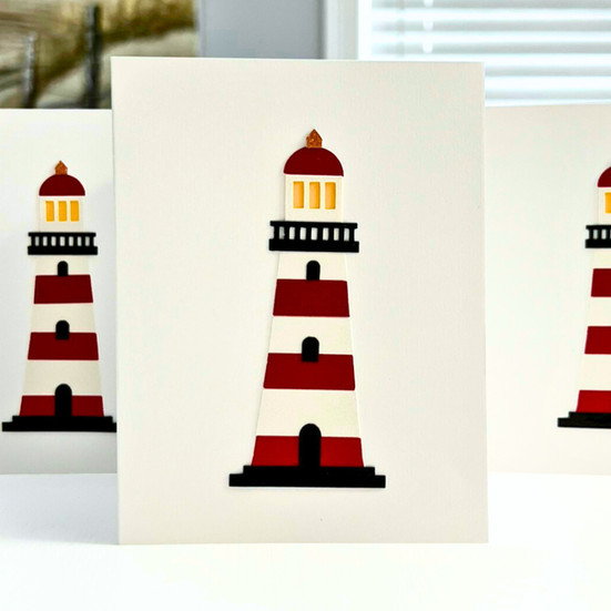
Trying to stay true to form, I started with an all‑white tower, but it didn’t hold space the way a lighthouse needs to — it disappeared on the card. Looking at real towers, West Quoddy showed how effective bold red‑and‑white bands are at giving a lighthouse presence, so I tried that approach in paper.
Each red and white layer is cut from no‑shed glitter cardstock. The shimmer catches light and gives the lighthouse presence, the same way bold daymarks help real towers stand out against fog and sea. The pieces are stacked with care so the lines stay true and the form feels steady, a small paper reflection of how the originals were built to endure.
The black cardstock railing, doors, and windows add a sense of interest — reminders that these were working structures tended by real people. A bit of yellow cardstock sits behind the lantern room to give the feeling of light and use, and the tower is finished with a warm copper top. Most lantern roofs are black, but it felt a little flat on the card; the copper glitter paper adds just the right amount of sparkle.
All of these choices reflect an effort to honor the function and presence of Maine’s lighthouses — not just their shape, but what they were built to do.
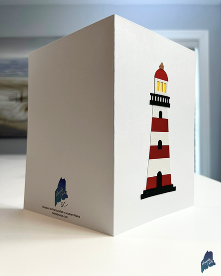
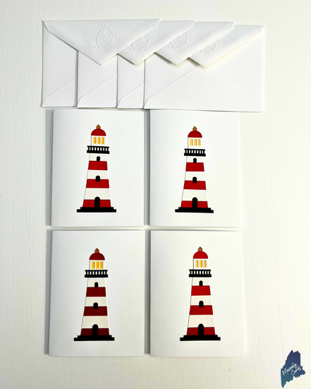
Discover our Red and White Paper Lighthouse Cards
The Red and White Lighthouse is available in multiple formats within the Mainely Cards shop. The same handcrafted layered design is offered as:
one full-size A7 greeting card
Buy 1 + Donate 1 (two full-size A7 greeting cards, one donated to Wicked Good Cards and one to keep)
a boxed set of four or eight A2 notecards
From Card to Connection
Spending time with Maine’s lighthouses taught me that their power isn’t just in how they look, but in what they’re created to do. They exist to guide, to steady, to reach outward.
A card does that, too. It reaches across distance.
Our lighthouse cards are small, intentional structures created to help you reach someone who matters.
Built with purpose. Sent with purpose.
From Maine,
Shannon


